So off I went. Just a few miles out of town I took a slight detour to check out subway cave which was slightly off trail. It was an amazing cave formed as a lava tube by volcanic a eruption in the distant past. I met another hiker named Lego there and we walked the short side trail to the cave and down into the underground. The cave was large and deliciously cool with a year round temperature of 46 degrees. It was a smooth tunnel through the earth. We walked into the dark with our lamps lighting the way. In one end and out the other a short while later, back into the blazing sun. I wished I could have just stayed in the nice cool underground for the day but I had miles to make so I headed on back to the PCT. I was following the rim with a drop off to my left down into the valley far below and a view of distant mountains further on. It was scrub brush, dirt and lava rock I strode on in the withering heat. I was hiking in a daze daydreaming of endless water and pizza buffets when I heard a rattle and the remnants of my ancient lizard brain screamed MOVEMENT! as I was setting down my right foot mid stride. I hopped to the side of the trail in what I’m sure was an extremely graceful leap and looked down at the large rattlesnake that I had nearly stepped on. It angrily rattled its warning as it slithered off the trail into its nearby den. I snapped a few pics and hiked on. Happy I hadn’t been bit.
I was conserving water sipping slowly whenever my mouth felt dry. I walked 10 miles and took a short break in some sparse shade still roasting hot but at least out of the direct sunlight. I couldn’t linger long as I had to make it to the water. Lego passed me by and hiked on following his own quest to strike liquid gold and survive the night. I was soon on my way again as well and watched the sunset over the hills. It was a spectacular show and as the last rays of light faded from the day I pulled out my headlamp to light my way. I could soon see Legos headlamp bobbing in the distance as well.
I caught up with him at a road crossing as he was looking for where the trail crosses in the dark of night. I looked it up on guthooks and we were back on our way. The lava rocks were the same color as the dirt making it perilous to hike fast. Still I made good time tripping over a hidden rock every few feet it seemed. Shortly after 11 pm I reached the road and turned left for the short walk down to the water cache. It was a 500 gallon tank maintained by a friendly local to keep hikers from dying in the desert. I filled up and drank a liter then set up my tent in a nearby flat area and just before midnight fell asleep without even having dinner.
On the 21st the following morning I was still up with the dawn hiking out while the sun was still yawning. Though I was a bit later than usual. There had been other hikers camped nearby but they had all left out already except Lego and Wildcat , a hiker I had met once before. I said my good mornings and see you laters and got back on trail. I had a great plan for the day. It was like 15 miles to a turnoff that led to Burney Mountain Guest Ranch where I planned to take a break grab some lunch and then get back on trail and hike a few more miles. As I hiked the sun fully awoke with a raging torrent. It baked the desert, dancing waves of heat flared across my trail. Nothing stirred as all life sought shelter, any movement risked heatstroke and dehydration. Still I marched on, my feet relentlessly taking step after step. Smoke from nearby fires blew through the wastes. The few scant trees seemed to be wilting even as I walked by. Cacti sweltered,and on I went. From my camp it was 14 miles to the next water spot and I eventually made it there and drank. From there I made it the few miles on across the river and around a reservoir till I hit a power line and the turnoff that went less than a mile to the left to Burney Mountain Guest Ranch. They had a store with food and sodas and premade breakfast burritos ready to be heated. I found Uphill there and Wildcat (she had overheated and hitched in from a deserted gravel road somehow) and I met Bojangles, and Amsterdam, and several others. I was planning to leave but it was the hottest day of the year so far and there was a bunkhouse and a pool and I hadn’t hung out with other hikers on the trail much this year. I won’t say it took much convincing and I stayed. I ate and drank too many sodas and swam in the pool. I had homemade lasagna for dinner around the picnic table with my new trail family and after dinner put a new tip on my hiking pole. It took a wrench, 2 pair of vice grips, a pocket knife and way too much time to get the old one off but with the moral support of the large white ranch dog I eventually succeeded. That night I was in the bunkhouse with 6 other hikers but my top bunk was swelteringly hot and stuffy so I couldn’t sleep. I grabbed my bag and went out on the wide front porch and slept in the cool night air.
The next morning at 4 am on the 22nd I was up and packing. I hadn’t been making any miles and was ready to go. Everyone else except for Uphill was taking a zero day there (day off) and I was glad I had slept on the porch so I could pack up without waking everybody up. uphill was up as well and made his way out of the room as quietly as possible then we hiked out. We made our way back to the trail and hiked on in the dark. I was looking forward to the day cause we were going to see the waterfall at Burney Falls State Park just around 10 miles away. We made good time and entered the park just before 8 AM. Our first stop was the store hoping for coffee and breakfast sandwiches but it wasn’t going to open till 9 so we left our packs at a nearby picnic table and went to find the trail down to the falls. It was close by and the falls were quickly in view. They were breathtaking. Multiple creeks and streams formed a wall of cascading water plummeting 129 feet and several hundred feet across into a deep translucent pool as Black Swifts dived and swept about. Moss covered trees and hoary boulders stuck out in random places and the spray reached us 100 yards away. Mesmerized I watched the falls wandering what it is about falling water that fascinates us so. After a while Uphill and walked back up to the top and returned to the store knowing we had many more miles to go. We had coffee and snacks. The deli was closed due to COVID but there were microwaveable breakfast sandwiches so we ate at the picnic table and hiked out. We continued on thru the park and out the other side hiking through forests up hill and down. It was another hot sunny day in California. As the afternoon waned we made our way to a dirt forest rod where there was a few campspots and Peavine Creek . The creek was hidden deep in the brush but flowing well so we set up camp and filtered water for the night. Camp chores and dinner and an early bedtime followed: another day on the trail at an end. Mile 1432.7 a 23 mile day.
The 23rd came all too early as I hiked out at 430 in the morning. It was a beautiful sunrise as we finished our climb up Red mountain. Most of the day was spent up on the ridges as we hiked through the forests and meadows. We passed deadman creek and Kodak spring climbing up and down and around the ridge. We enjoyed the cool morning and sweltered in the afternoon heat. We were trying to make miles and hiked till 5 in the afternoon; a 13 and a half hour day. We considered going on but decided to stop at Deer Creek where we could camp by the water and not have to dry camp for the night. It was a 29.4 mile day to mile 1461.6.
I slept well at Deer Creek and awoke before the dawn on the 24th and packed up. Uphill packed up as well and we were both on trail before 5 AM. We actually got to hike down for a while to Centipede Gulch and crossed over the McCloud River. There was a pit toilet nearby that was supposedly full of bats and quano. I was going to check it out but there were people camped near it and I didn’t want to bother them so I just crossed the bridge and and took a break on the other side watching the river. Afterwards I hiked on. Uphill hikes way faster than me and he floated off up the hill as I settled in for a long slow climb. I passed Fitzhugh gulch and walked up and around-skunk hill. I reached the top of the climb and made my way down to another saddle to Squaw Valley creek ten miles further on. I crossed the bridge and took the short side trail to Cabin creek Trail head where the creek was more accessible for water and to take a break. There was a parking lot there and as I sat down to filter the water I had gotten from the creek a couple of gentlemen walked up and asked what I was doing. I explained I was hiking the PCT and answered all their questions. They told me they were Vietnam veterans doing some traveling together. They asked why I had duct tape wrapped around my hand and I told them I had a weird puncture wound from a splinter that I didn’t want to get infected and duck tape was all I had to keep dirt out of it. Ed went back to their car and got gauze and tape and Neosporin and told me to take it. They told me I was like a character from a book and took pictures and then we parted ways. It was getting close to 4 pm and I realized I was not going to make it over the next mountain to the next water source that afternoon which meant I would have to get enough water for the night there at the creek and carry it to the campsite up the hill. Water is heavy and carrying extra is never fun but I had little choice so I filled my bottles and my water bladder and set off up the mountain. I made it another couple of miles and another 1200 feet of ascension and reached a nice campsite where I stopped for the night. At camp I realized I had lost one of my camp shoes somewhere but I wasn’t going back down there mountain to look for it. It was sad: They were hoka recovery slippers the greatest camp shoes ever! They’re usually really expensive but I had gotten mine at a used gear store in Bishop CA for next to nothing: it was a sad moment on the trail. I went ahead and made dinner and a little after 6 a Nobo hiker came by and said he was called Guerrilla. He was hiking on over the mountain to the next water source so I told him to keep an eye out for Uphill since I figured that’s where he was and tell him I was on the south side of the climb. Guerrilla hiked on and I finished my dinner and crashed for the night. I was at mile 1486.7 a 25.1 mile day.
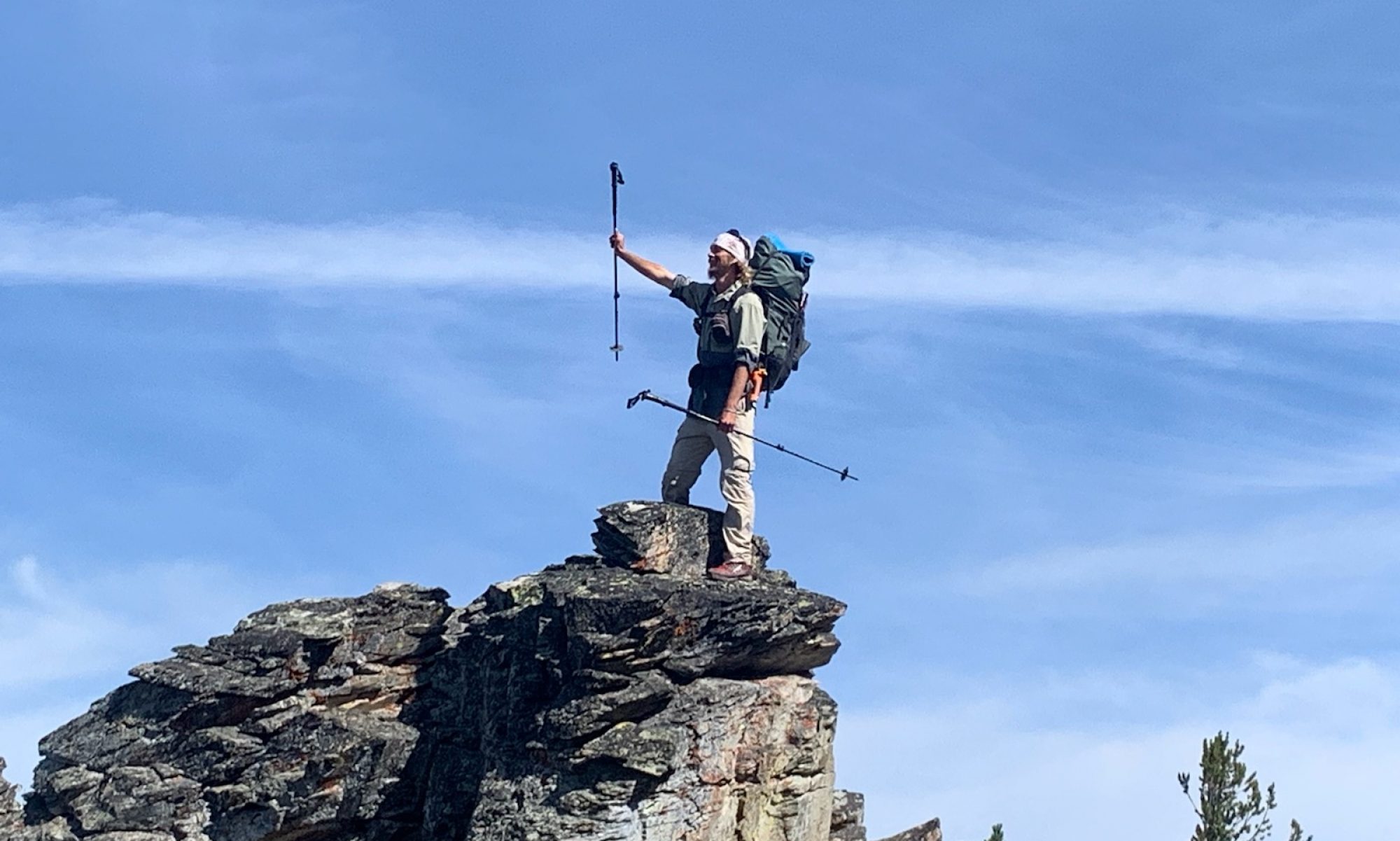
The following mornin on the 25th I started even earlier at 330 AM. I was sad about the loss of my camp shoe and still carrying one since I couldn’t just leave it in the woods. I had a chance to go to town that day but had planned on skipping it since I was still carrying way too much food from the box I had received in Old Station. I was torn on what to do as I climbed the mountain side. The trail had taken my shoe to force me to go to town. (I tried to skip Truckee and my shoes fell apart earlier on this trail.) so I decided if I found Uphill before I made it to the highway so I could split the shuttle cost I would go into town to eat, get snacks and buy another set of camp shoes. I crossed over the mountain and started my way down. I climbed up onto an old logging road that paralleled the trail for a while cause it had spectacular views of the sunrise over Mount Shasta and Castle Crags. As I reached the end of the road I saw Uphill on the trail in the trees just to my left. I had found him; and just then we walked up on Guerrillas campsite. We all said our good mornings as we took in the majestic Mt Shatna in the distance then Uphill and I headed on down the mountain towards the highway while Guerrilla gathered his gear.
We reached the Cascade Wonderland Highway also know as interstate 5 and called a number from a note that had been left on a tree. The number hooked uphill to a lady called Kellyfish who would be happy to come get us and Guerrilla (who had walked up) and take us to Mt Shasta for 20 bucks. So we hung out until she arrived then hopped in the car. She dropped us off at the Black Bear cafe where they had a tent setup in the parking lot so they could serve customers. We all ordered coffee and I got pancakes and bacon. It was delicious and I was very happy I had come to town. Afterwards Uphill and I walked across the street to RiteAid for snacks and drinks and I looked for a cheap pair of offbrand crocs but had no luck. From there I went to the gear store and had no luck their either then to the outfitters also with no luck. Apparently cheap rubber Chinese shoes are in short supply during the pandemic. I even checked the Ace hardware store. There was only one place left to check, the Sierra Trading Post, but they weren’t open till 11 and it was only 1030 so Uphill and I walked down to a local Mexican place that had outdoor seating and had an early lunch of burritos. I was having a great day! After lunch We went back to the Trading Post and I bought the only pair of rubber slippers they had;ugly white things; and paid too much for them but they work well. I walked with uphill over to the laundry mat and started calling around for a ride out of town. Uphill was staying the night but I was ready to hike. I got no love from Uber or Lyft and KellyFish wasn’t answering but I got the number for a guy called Nightwing off the guthooks comments and he said he’d take me back to the trail for 25 bucks. I agreed and he showed up 15 minutes later and drove me back to where I had gotten off.
It was 1230 and I was back on trail after a successful town stop. From there I walked into Castle Crags state park and started a ridiculously long 33 mile climb. All afternoon I slowly made my way uphill. It was a lovely trail through the trees in the afternoon heat. I climbed on and on until I reached a water source known as disappearing creek that had a couple of small tent sites and set up camp. I had climbed ten miles since town and was tired. The creek was further in past a small rock climb and came straight out of the mountainside falling down into a small pool and then disappearing back into the mountain. It was a beautiful spot and my favor water source on trail so far. I sat and relaxed by the small falls and then headed back to my camp which had been invaded by a legion of mosquitos while I was absent. I quickly escaped to the safety of my canvas abode and cooked and ate my dinner inside before sleeping. Mile 1511.3 a 24.6 mile day.
The 26 th I awoke with a 22 mile climb still ahead. It was going to be a long slow day. The views of MT Shasta and Castle Crags made it better but it was still an endless uphill slog. I am super slow hiking up so I wasn’t making good time at all. I only had 8 miles in at 10 and barely 11 at noon. I slogged on hoping to reach the peak. As the afternoon waned clouds began to cover the peaks and distant thunder rumbled. I considered stopping at 20 miles and camping next to Porcupine lake but it was full of people that had waddled in from the nearby road and parking area. There was music blasting, garbage flying about, mayhem and noise. I hiked on. I made it another couple of miles and finally reached the top. The wind was picking up and the storm would soon arrive. I crossed and started down the other side looking for a place to camp. There was nowhere, I was walking on the steep side of the mountain without a flat place anywhere in sight. I was trying to beat the rain and half jogging down the mountainside when I came to a side trail for a spring that looked like it led to a flattish area. I went for it and followed down into a grove of pines. There in the middle was a relatively flat area that was mostly somewhat free of rocks and I quickly set up my tent and got inside just as the rain began to fall. I was safe and dry as I cooked and ate and fell asleep listening to the rain. Mile 1534 a 22.7 mile day.
The 27th the storm had blown by but as I woke up I smelled smoke. As I exited the tent the air was full of it. I assumed the lightning the night before had ignited brush fires and I could only hope they weren’t too close. I knew California had several wildfires burning but so far they hadn’t affected the trail. The smoke wasn’t too bad and I was able to start hiking before sunrise. Somehow it was mostly uphill again and as the sun rose I realized the trail was going south in a huge circle. It was as though the trail builders had run out of hills to climb so they had turned back to catch the few they’d missed. Needless to say this was a bit demotivating and I was having a rough day. I was tired of walking uphill in circles and that was basically the trail in Northern California all day everyday. The scenery was beautiful though with Mt Shasta in the distance and the granite pillars of Castle Crags. I reminded myself that I was hiking the PCT and I would go where it led. Still it was a slow day as I tried to motivate myself to climb. I took a long lunch and a long afternoon break. Smoke still filled the air as I finally got to hike down for a bit to highway 3. It was already after 5 but there was no water there so I had to climb again and make it another two miles to a stream and campsite at mile 1564.9 where I sat up my tent and spent the night. A 30.9 mile day.
The 28th I was trying to figure out what the quickest way was to get out of California. Oregon was the promised land. Supposedly it was cooler, flatter, and way shadier. It was still 126.8 miles away. I decided if I skipped the next town Etna and hiked on I could be there on the 1st of October with a stop in Seiad Valley for a quick resupply. So that was my plan escape from California as quickly as possible. I still had plenty of food from the huge box my dad had mailed me at Old Station so I got out of my tent and set off determined to make miles. It was another day of walking uphill in circles and I made slow time. The morning started with a 5 mile climb up past Eagle Peak. As always I enjoyed the sunrise and was happy to be hiking the trail. As the morning waned on I was struggling to stay focused and make the miles I had planned on a 35 mile day but was quickly realizing it wasn’t going to happen. I was tired the smoke and heat and constant climbing was wearing me out mentally and physically. I crossed forest Highway 93 and met the helicopter crew for the bird that was fighting the nearby fires. The mechanic and fuel truck was using the trail parking lot. The help would go and scoop water out of the rivers and dump it on the fire: then when it got low on fuel it would come there, land and refuel before and go do it all over again. They gave me some Gatorade and a cold bottle of water and I sat there in a shady spot and chatted for a while. We discussed the brief but exciting journey of the fish that got scooped up by the helicopter with the river water and then dumped on the fire. It was a great lunch break but I had to hike on so off I went. I passed Carter meadows and Jackson Lake. Around 3 I sat down for a break and fell asleep. I woke up about 20 mins later and knew I was not making it much further but I still needed to make it to water if I wanted to eat dinner as I wasn’t carrying much. I started off up the hill and not 15 minutes later I heard “Wallace” from close behind. I turned around and Uphill was running up behind me. I had left him in Mount Shasta but he hiked way faster than me and caught up. We hiked on from there to Statue creek and set up camp for the night. Mile 1590.8 a 25.9 mile day.
The next morning on the 29th Uphill needed to go to town, he was running low on food. The road to Etna was only 8.9 miles away. I had previously decided not to go in but with promise of breakfast and real coffee and maybe even a toilet I was sold so we woke early and ran to the road. we got there by 8 and an awesome hiker had left a cooler ivy his pickup with cold sodas and a box of chips so we partook and then stuck out our thumbs. In a COVID world sometimes hitchhiking takes a while and for the fires jour and a half or so people drove by looking at us like we were crazy but then a local rancher picked us up in his truck and we were on our way. He dropped us off in town and we walked to the cafe where we ate breakfast and drank coffee then went to the dollar store and I bought a few snacks and Uphill resupplied. Then we went back to the cafe and had coffees and blackberry pie. Uphill made friends with a local. They were both avid fly fishermen: and the guy offered to take us back to the trail he had lived 10 miles east out of town off and on for 20 years and had never seen anything west of town beyond the city limits He was amazed at the Mountain Views as he drove us west back to the trail.
We hopped back on and got to hiking. It was already 1230 in the afternoon and we had a goal. There was only one way we were making it to Oregon on the 1st we had to do just over another 15 miles to a tent site that was 40.8 miles from Seiad valley. Tomorrow would be our first 40 plus mile day. Or at least an attempt at one. So we hiked up and out. We walked all afternoon and passed fisher lake and made it to mile 1615.1 where there were tent spots and water. Dr Suess (trail name not real one) and his wife hiked in shortly after and we visited before retiring for the night.
The morning of the 30th Uphill and I were up at 2 am and hiking by 230. It was a beautiful night. I had cowboy camped that night, and woke up to clear infinite stars. I stared too long as my mind attempted to grasp the scope and depth of the starscape. I reluctantly pulled my eyes away and packed up my gear. We were headed for Sead Valley 40.8 miles away. I had never done a 40 on trail before and said I never would but I really wanted to get out of California and the last 20 miles were kinda sorta mostly downhill. But first we had to climb. So up we went, up and over as the dawn arrived we were watching the spectacular sunrise in the distance. A steady glow orange rising above the peaks. Somewhere there I missed an unmarked turn and we were over half a mile down the wrong trail when I heard Uphill yell “Wallace, stop we’re on the wrong trail.” So we turned around and walked back to where the trail had plunged right off the ridge without any sign at all and I had missed it in the twilight of early dawn. We took the turn and walked on down to an abandoned forest service cabin where there was a creek and we took a breakfast and water break. We saw another hiker we had met before and said hello then took off again. Uphill went on and I settled in for a long hike. It was another climb in the morning but I actually made good time and reached the highest point of the day shortly after 10 am. I passed thru Tyler meadows and reached the top of the nearly 22 mile descent down to Sead Valley the lowest point on trail. I passed Buckhorn spring and filled up my water bottles. The trail led through the forest and was mostly good walking for the first few miles. I stopped at a shady spot and ate lunch with a friendly deer. (They wait for hikers to pee so they can lick up the salt). After lunch I hit what hikers in front of me had termed the bushwackalypse. The trail was completely overgrown with bushes and I had to push myself through. In some place they were over my head and I couldn’t see any of the trail. This went on off and on for miles. The trail passed over Grider creek on a nice bridge and followed alongside, up and down like a roller coaster. I was 30 miles in by 2 pm and feeling it but I pushed on. The store in town closed at 7 and I was hoping to be there. I crossed Grider creek a couple of more times both on nice bridges as I continued to descend. Eventually I reached a gravel road and from there it was a 6.3 mile road walk into town. The road walk was officially part of the trail so I had to walk it. I walked past an older hiker sitting under a tree and he told me Uphill had ran by a little while before. As the gravel road turned onto a highway I hit my 1000 mile mark on the PCT at mile 1652.1. It was also my 50th day on trail. I stopped and made a 1000 mile marker out of rocks and took a pic to commemorate the moment. Then I walked on down the pavement int the hot sun. The trail made a big u down the road across the river in a bridge and the back to town the town was actually only a shirt half mile away on the other side of the water I was walking beside but I wasn’t allowed to cross due to the hiker hating landowner. Apparently there used to be access and a bridge but it was shed out and the owner refused to let it be rebuilt and decide the doesn’t want hikers crossing his land. I heard the PCTA even tried to buy it and he refused to sell. So I took the long away around. I passed the less than 1000 miles to Canada mark a mile after my thousand mile one. I took the paved road out to the highway and turned back west to walk to the bridge across the river. A white suburban passed me and went just past the bridge and pulled over to the side. I walked on and as I got close to it a lady got out and really wanted to give me a ride. I looked at at my map and I was at 40. 4 miles for the day and it was about half a mile to the store so I agreed. She wanted to take me past the store to the wildwood lodge where she worked but I asked her to drop me off there cause my box was at the rv park next door and I had to meet Uphill. She concurred and dropped me off before continuing on her way. I walked in and found Uphill buying snacks. I bought some as well and then asked the store owner if he knew what time the Wildwood closed since it was the only place it town that serves dinner. The cafe next to the store had closed at 2. He said the Wildwood was shutdown and that it had only been opened to run him out of business and other derogatory things. I was confused since I had just ridden in with the employee, but apparently there was a huge rivalry going on in the town and the old businesses hated the new one for taking their business away and were trying to deter folks from going there but nobody in the main town served dinner and hikers are going to go where the food is. We left the store and walked next door to the RV park where the awesome owner Bruce gave me my resupply box. He had held it for free: and he got us set up to camp for the night. We got to camp on soft grass for 15 bucks and had an awning with plugs and a fridge; warm showers and 3 dollars for laundry. There were outdoor swings to sit on next to camp as well it was an awesome relaxing place. Uphill told me his box was at the post office which didn’t open till noon the next day. So we would have to hang out in town all morning. That was fine with me we had already planned to do a short day the 31st because it was a 4500 foot ascent over 9 miles to get out of Sead valley. I called Wildwood and the lady said she was serving burritos to hikers till 9 and there were a bunch camping up there if we wanted to come eat. By the time we showered and did laundry it was well after 8 and it was a half mile walk so we decided not to go. We ate camp food and snacks and drank sodas we had bought at the store before it closed. It was a great evening hanging out and relaxing celebrating our 40 plus mile nearo into town. As I fell asleep, camped on the nice soft grass I was perfectly content.


Wow! I enjoy reading every word! The pictures are awesome! I can only imagine how beautiful all these places are! Enjoy and journey on!!! Mom
Thank you so glad ur enjoying it